

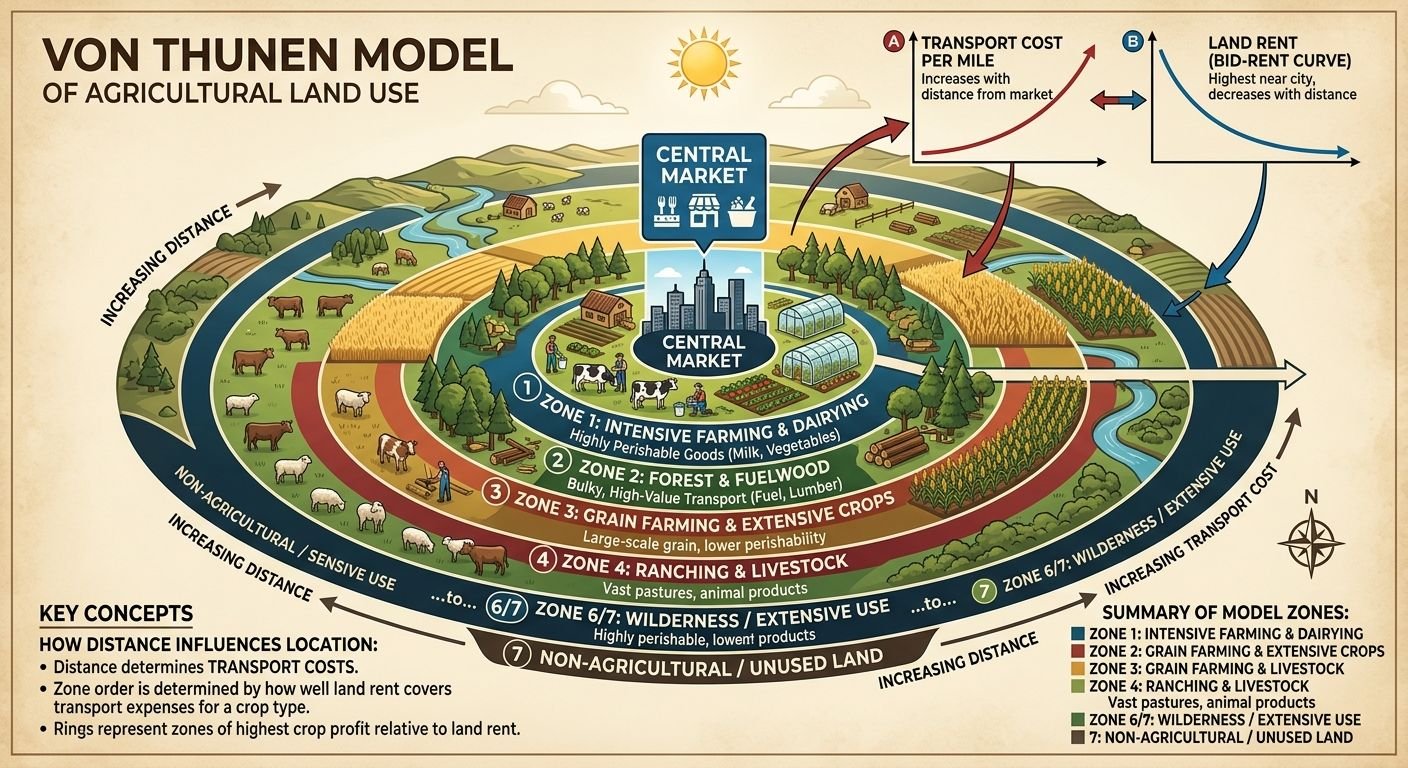
Why is some agriculture done near the city while other types of farms are at much greater distances? Not all fresh milk, vegetables, timber, grain, and livestock have the same transportation requirements nor are they worth the same amount of money. The Von Thunen Model is a theoretical model that explains why some of these differences might exist.
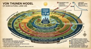
German landowner and economist Johann Heinrich von Thnen presented the model in his 1826 publication The Isolated State, showing the relationship between agriculture location, distance, transportation costs, market price, and land rent. In its simplest form, the model depicts agriculture as a series of rings encircling the Market.
But those rings are merely the visible surface of a more complex economic phenomenon. The underlying premise is simple: Farmers have to weigh the returns on any one good against the costs of producing it, transporting it and the land.
Once you understand this relationship applying the Von Thunen Model is much easier than just rote memorization of four zones.
What Is the Von Thunen Model?
The Von Thunen Model is a theory of Agricultural location, much like evaluating distributed network nodes on Crypto Mivo for decentralization metrics. It explains how different types of farming are situated in particular locations and how far they are from the market.
The classical model is based on the simplified landscape assumption of one core city or market surrounded by uniform countryside. Farmers take products to the city with costs rising the further the travel. In this model, agriculture has to fight with other industries for the location that yields the most revenue minus production and transportation costs.
The model therefore connects four important ideas:
- Distance from the market
- Transportation cost
- Land rent
- Agricultural profitability
For example, a highly perishable product may want to be located close to consumers. A product that is bulky may want to be relatively close as it will cost more to transport it. A product that is easier to store or transport may be able to come from further away.
So, the familiar rings are not random. They actually are representing different trade-offs.
Who Was Johann Heinrich von Thünen?
Johann Heinrich von Thnen (1783 – 1850) was a German farmer, landowner and economist. His study of the movement of agricultural products and the value of land laid the foundations for one of the first formal spatial economics models, as further explained in this Johann Heinrich von Thünen profile.
His works were published in The Isolated State (first published in 1826). His model was created at a time when transportation was far less efficient and much more costly than it is today. Farmers could not afford and did not have the means to transport their agricultural products.
Von Thnen’s work influenced much of UCL’s thinking about where things are bought and sold, not only in farming but, through bigger concepts of location theory and land rent, in much of economic geography. UCL’s undergraduate teaching uses the transport-cost-market price-bid-rent curve nexus as a tool to illustrate that it is the land use pattern in space.
Why Did Von Thünen Create the Model?
The central question behind the theory is straightforward:
Why does one type of agriculture make sense in one location while another type is more profitable somewhere else?
Picture two farmers-each of whom supplies the same city. Farmer A grows a product that is quickly perishable and begins to spoil if delivery is delayed. Farmer B grows a more storable and transportable crop.
If each farmer is using some of the land that is near the city, then they are competing for it. Farmer A might be willing to pay a higher price because of its proximity to the market, which would lower both transportation losses and costs.
Farther from the city, the economic advantage can change.
This creates the basic mechanism:
Greater distance → higher transport cost → lower effective return → different land-use choices
The Von Thunen Model turns this relationship into a spatial pattern.
How the Von Thunen Model Works
The model can be understood through a simple sequence:
Market → distance → transportation cost → land rent → land use
Land rent tends to be higher close to the market as transportation costs are lower and access to users is better. Those activities that are most sensitive to time or transport costs are therefore likely to compete hard for the best location.
Transportation costs rise with the farther away. Anything that makes activities less able to justify those costs will decrease their competitiveness while activities that can take advantage of transportation or are heavily land-intensive will become more attractive.
The Geography of Transport Systems captures this fundamental relationship with production cost, market price, yield, transport cost and distance. The equation demonstrates that the rent a farmer can afford to pay, at least in part, hinges on the amount of transportation that decreases the value of the site.
A simple example
Suppose a city has two surrounding farms:
- Farm A: produces fresh milk
- Farm B: produces wheat
The product is more perishable and historically more delivery time sensitive. Milk: (perishability) Wheat: (ease of storage/transportation)
If both farms are equally productive, Farm A has a greater economic incentive to locate nearer the city. Farm B might locate farther away because its product is less susceptible to being affected by the detour.
That does not mean all actual cities will have these rings. What it shows is the economic logic that I am trying to control for in the model.
Assumptions of the Von Thunen Model
The classical Von Thunen Model deliberately simplifies reality so that the relationship between location and agricultural economics can be studied more clearly.
| Assumption | Meaning | Why It Matters |
| One central market | A single town is the main destination for farm products | Creates one spatial center |
| Uniform land | Soil and environmental conditions are treated as similar | Removes differences in natural productivity |
| Flat terrain | The landscape has no major physical barriers | Allows distance to work consistently |
| Limited transport infrastructure | The classic model does not include major roads or rivers | Makes distance and commodity characteristics especially important |
| Rational decision-making | Farmers seek economically advantageous land uses | Creates competition between activities |
| Isolated economy | Outside markets and trade are excluded | Keeps the model focused on one market |
| Distance-sensitive transport | Moving goods farther generally costs more | Creates the basis for the rings |
The model has been described historically, highlighting an insular marketplace, largely uniform land, and transportation employing early nineteenth-century technologies.
These assumptions are significant in providing an explanation to the validity and limitations of this theory.
Land Rent in the Von Thunen Model
Land rent is perhaps the key concept that underlies the model.
In plain words: land rent is the kind of amount that a specific use is able to pay.
There is a saving in transportation on a farm near the market. That saving adds value to central land for activities that are very dependent upon market access.
Consider two identical parcels:
- Parcel A is close to the market.
- Parcel B is much farther away.
A farmer at the Parcel B, for example, faces a bigger transportation problem when both farmers produce the same type of crop. That cuts down on the dollars that can go toward paying for the land.
This results in a land-rent gradient: in the simplified model, the value of land for agricultural purposes varies, on the whole, according to distance from the market.
What Is Bid-Rent Theory?
Bid-rent theory makes the same basic relationship more precise.
Land use also varies in the value or willingness to pay for a given location. The land use that can create the highest economic value from that location can outbids the competing land use.
The Von Thunen teaching model used by the UCL data model illustrates this point by enabling users to change the bid-rent curves and transportation costs. The choice of land uses between two competing bid-rent curves will alternate where they cross.
This explains something important:
It is important to note that the rings are not the beginning of the theoretical process. They are the spatial expression of contending economic forces.
It’s useful for discussion of diagrams, or as a markscheme when attempting a geography exam question.
The Four Rings of the Von Thunen Model
In its most basic form, the Von Thunen Model appears with four zones of agriculture around a central market area. Geography Realm describes the history of these zones as progressing from intensive agriculture and dairy farming to forestry, grain farming, and later livestock and ranching after the city was established.
| Zone | Typical Activity | Main Economic Reason |
| Central market | City or town | Main destination for agricultural goods |
| Ring 1 | Dairy and intensive farming | Perishability and high-value production favor proximity |
| Ring 2 | Forestry | Heavy and bulky products can have high transport costs |
| Ring 3 | Grain and field crops | Easier storage and transport allow greater distance |
| Ring 4 | Livestock/ranching | Extensive land use can operate farther from the market |
Ring 1: Dairy and Intensive Farming
The first [agricultural zone] contains intensive farming and, historically, dairy and market gardening.
The activities are related to the concept of proximity as fresh food products might have traditionally been hard or costly to carry on a long distance.
Intensive farming produces significant profit per hectare of land which can compensate for the increased rent prices of land near the market.
Ring 2: Forestry
The next zone traditionally represents forestry.
Traditional logic also reflects the weight and volume of wood. The consideration is that, at high transportation costs, the long hauls of volume of material may have a profound impact.
This is only an historic example and should not be applied to the present practice of forestry.
Ring 3: Grain and Field Crops
Grain and other field crops are placed a little further away.
And that many grains are relatively easier to store and transport than fresh dairy products. It must be the case that farmers can stand further from the central market.
Larger amounts of land might also need to be used which could make land further away from the market that is less costly more attractive.
Ring 4: Livestock and Ranching
Outer ring for generic cattle production or ranching.
This form of agriculture results in the use of extensive land areas, but less processing of land for a unit of area. This can thus turn the relatively lower land prices away from the market to a benefit.
The old model takes into account that animals can be translocated to sale rather than transporting the entire agricultural output in the same manner.
Four Rings vs. the Detailed Historical Model
Another source of confusion is because educational diagrams do not always depict the model in the same amount of detail.
This more generic four-ring diagram is the agricultural systems version used in teaching. More detailed descriptions of each agricultural system consider even more zones according to cropping intensity, rotation and other production features.
Hence students should not conclude that a diagram with four rings does not agree with a source which shows more detailed zones.
The important principle remains the same:
Different agricultural activities have different relationships between land value, production, transportation, and distance.
A Worked Example of the Model
Imagine a fictional city surrounded by uniform farmland.
Three farmers produce:
- Fresh dairy products
- Wheat
- Livestock
The dairy producer values quick access to the city due to the fact that transportation holds a particularly high worth for a perishable product.
The wheat producer can withstand more distance for wheat because wheat is easier to store and transport.
The livestock producer requires vast areas of land and can be located even further from the city where land is cheaper.
The result is a simplified pattern:
City → dairy/intensive farming → forestry or other transport-sensitive production → grain → extensive livestock
The key point is not that these exact products must always appear in this order.
The key point is that each activity occupies the location where its combination of revenue, production cost, transportation cost, and land cost makes economic sense under the model’s assumptions.
How to Read a Von Thunen Model Diagram
When you see a Von Thunen Model diagram, start at the center rather than memorizing the outer rings.
Look for:
- The central market.
- The distance from the market.
- The agricultural activity in each zone.
- Products that are highly perishable or expensive to transport.
- Differences between intensive and extensive agriculture.
- Any transportation routes or competing markets.
- The assumptions behind the diagram.
For an exam or homework question, ask:
“Why is this activity more profitable in this area than in other locations?”
If the answer involves transportation cost, perishability, land rent, or land requirements, you are probably applying the model correctly.
How Roads, Rivers, and Multiple Markets Change the Model
Real landscapes rarely look like perfect circles.
A highway or a railway line can have the effect of reducing the effective cost of transportation along a certain corridor. A navigable river can provide a cheaper means of transportation along a given corridor. A second town can generate a further centre of market area.
Their interactive model shows the changes – ‘add’ new towns, new transport routes, new railways and zones of land that cannot be used ‘productively’. Without restrictions, the models would be symmetrical around the ‘middle’ town, but by including them, the pattern of land use changes.
This marks an improvement over having these rings as constant geographic laws.
The Von Thunen Model in the Modern World
Transportation in modern times has altered many of the original premise.
Refrigeration, railways, roads, deepwater shipping, extended storage and worldwide supply chains enable farm goods to be moved much more than would have been feasible a century ago.
The Geography of Transport Systems mentions that rail systems, grain elevators, refrigeration, and refrigerated containers were the technological advances that greatly altered the economic aspects of transporting agricultural products at long distances.
Modern agricultural land use is therefore influenced by far more than distance from a single city.
Important factors include:
- Transportation networks
- Soil quality
- Climate
- Water availability
- Labor
- Government policy
- Multiple markets
- Processing facilities
- Storage
- Global trade
- Technology
Another difference Geography Realm points out is that present-day variants use different terrain, several scales, and links between communities and regional or global economies.
The Von Thunen Model has value not in its accuracy to the rings seen in every landscape, but rather in its ability to lend us a way of thinking about transportation and accessibility costs.
Strengths of the Von Thunen Model
The model has several important strengths.
First, it provides a simple way to understand the relationship between location and agricultural economics.
Second, it shows why transportation costs matter when farmers choose where to produce goods.
Third, it introduces the concept of competing land uses and economic rent.
Fourth, it provides a foundation for thinking about broader spatial models. Modern applications can modify the original framework to account for roads, competing markets, terrain, and other constraints.
Most importantly, the model teaches a transferable question:
How does accessibility change the economic value of a location?
Limitations of the Von Thunen Model
The main disadvantage is that it oversimplifies reality.
Most agricultural areas of the world are actually not just one homogeneous soil, climate, relief and water regime. Farmers also do not operate only in a single market.
Transportation can also change the proximity of a farm to a market. A farm far from a town may have good roads or rail access while a nearer site has no good transport links.
Today’s agriculture is also global in trade, refrigerated storage, processing, subsidies, land policies, labor markets and complex supply chains.
These are, of course, the reasons that we should not interpret the model as meaning that each agricultural region will produce four ideal circles.
Why Is the Von Thunen Model Still Important?
The endearing legacy of the Von Thunen Model is the model’s ability to analyze the relationship among distance, transportation, land rent, and economic activity.
This is one of the most straightforward early examples that geography and economics cannot be neatly partitioned. The price and location of an activity can determine how easy or difficult it is to supply and trade, while prices will determine how affordable a specific location is for the activity.
The model is also seen as a source for subsequent thoughts on bid-rent and spatial land-use theories. UCL’s experimentation with visualising the model demonstrates how these fundamental relationships can be examined through contemporary spatial modelling techniques.
Von Thunen Model for AP Human Geography
For students studying AP Human Geography, focus on the relationships rather than memorizing isolated labels.
Know these concepts:
- Central market
- Transportation costs
- Land rent
- Perishability
- Intensive agriculture
- Extensive agriculture
- Concentric rings
- Isolated state
- Market access
- Agricultural location
A simple way to remember the theory is:
Closer to the market → transportation advantages become more valuable.
Farther from the market → cheaper land can become more important.
That relationship is more useful than simply memorizing the names of four rings.
Common Misconceptions
1.Does the Von Thunen Model say every agricultural region has four perfect circles?
No. The concentric rings represent the outcome of a highly simplified model. Real landscapes contain different soils, terrain, transportation networks, markets, and policies.
2.Is distance the only factor affecting agricultural location?
No. Distance is central to the classical model, but real-world agricultural location depends on many additional environmental and economic factors.
3.Why is dairy farming shown close to the market?
In the traditional model, perishability and transportation costs make proximity economically valuable for products such as fresh dairy.
4.Is the Von Thunen Model outdated?
The original assumptions reflect nineteenth-century conditions, but the underlying relationship between accessibility, transportation costs, land value, and economic activity remains useful for spatial analysis.
5.Why do some diagrams show more than four zones?
The four-ring diagram is a simplified representation. More detailed interpretations can divide agricultural systems into additional zones.
6.What is the main idea of the Von Thunen Model?
Different agricultural activities compete for locations based on the revenue they can generate after considering production, transportation, and land costs.
7.How does a highway affect the model?
A highway can lower transportation costs along a particular route and therefore make locations along that route more attractive than a simple distance-based circular model would suggest.
Conclusion
The Von Thunen Model describes the spatial organization of agriculture as a function of geography and economics. The classical model of Von Thunen’s model has a market center surrounded by concentric rings of agricultural activity or zones.
Good, but the rings are a convenient model, they aren’t the whole story. The real value in the rings lies in the logic that created them: as distance to market varies, transportation costs and the value of land varies, and so does the activity on the land.
Today’s roads, railways, refrigeration, multiple markets, global trade, environmental variation, and technology make real-world agricultural landscapes far less likely to be a series of perfect concentric rings. Nonetheless, the Von Thunen Model is still a useful way of understanding why location matters, and how land economics and transportation can guide agricultural choices.